Today I went for a short walk in a small village called Qrendi. Qrendi is situated in the south west of the island, and is mainly composed of farmland. I walked along the outskirts of the village from another small village called Mqabba up to St Matthew's church.
This short walk is one straight road with farmland on one side, and the village on the other, as you can see in the image below. In the distance is another village called Zurrieq. (Yes Malta is that small).
 |
| Typical field in Qrendi |
 |
| Another typical field with prickly pears in the foreground |
Walking along the street, a long rubble wall with prickly pears leaning against it is the only thing separating the fields from the traffic zooming by. Prickly pears are a staple plant in the Maltese Islands , and even featured on our national emblem before it was replaced in the late eighties.
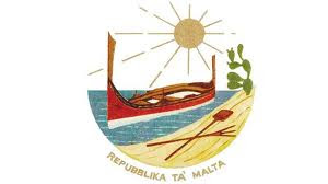 |
| Malta's national emblem till 1988 |
Prickly pears are commonly grown at the edges of fields along stone walls to protect the crops from high winds. As a result of this, the fruit is for anyone's taking.
 |
| Prickly pears from street level |
 |
| Flowering prickly pear |
Apart from the prickly pears I also came across these very tall flowers. They must be over ten feet tall, and I can't quite find a name for them. They could be Danish Hollyhock, but they are slightly different. Does anyone know what these are? I have also seen them in people's gardens, and they are cultivated, not found naturally here.
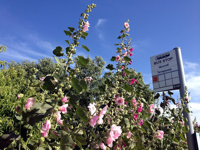 |
| Very tall flowers |
 |
| Danish Hollycock? |
Horses are also a common sight in the streets of Qrendi. I came across four in my short walk, trotting away in the street, oblivious to the cars rushing by beside them. The owners ride them up and down the same street a couple of times, supposedly for exercise, although I have seen a couple racing the horses; they just couldn't resist.
 |
| Horse riding in the street |
Towards the end of my journey, the buildings start making way to farmland. Most fields have been growing potatoes, and have been harvested by now. Here is a typical farmland setting complete with electricity pole standing in the middle.
 |
| Farmland |
 |
| Freshly harvested field |
At the end of my journey I come across the church of St Matthew. This is not the main church of Qrendi, but a small chapel, one of six in a village of a few thousand residents! This chapel, however houses what is most probably the oldest crypt on the island supposedly dating back the the 14th century.
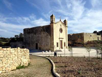 |
| St Matthew's Chapel |
The interesting story about this chapel though, is that in 1343 a tremor created a crater, 130 feet deep, right behind the chapel, but it was left standing there unharmed, and remains there to this day. In the image below you can see the church marked in red, and the crater, now full of trees and shrubs behind it. People can see the crater today via steps on the side of the church, but no one is allowed to go all the way down.
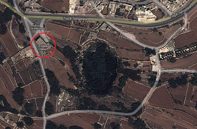 |
| Aerial view of the church and the crater thanks to Google Maps |
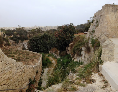 |
| Chapel at the edge with steps going down to the crater |
I hope you enjoyed my walk through Qrendi. This short walk and few pictures capture the gist of Maltese farmland. Across the country pockets of land like this still exist, giving us crops that no importer can match. Unfortunately they are shrinking every year as reckless development increases. I only hope that Qrendi will be one of the last villages to be swallowed by the concrete jungle that is turning our island into yet another European metropolis.


.JPG)


Thanks for taking me along with you on your walk! Qrendi is indeed a beautiful village, settled amidst gorgeous scenery. It must be amazing to stand on the church steps and look down into that crater!
ReplyDeleteHello Deb, thanks for stopping by, glad you liked the place.
ReplyDeleteThank you for including us on your walk. I don't know much about this part of the world and so I found it very interesting to read your text and see the pictures. The tall flowers definitely look like hollyhocks to me. The crater sounds very mysterious. I wonder how deep it is?
ReplyDeleteHi Jennifer,
ReplyDeletethanks for stopping by. The crater is around 130 feet deep, I just corrected the post as I realized I didn't say it was 130 feet deep!
Thank you for your comments and observations about Qrendi. May this be one of many others that follow as there is alot awaiting to be discovered within and on the outside of our village, and that include its beauty, its monuments, and best of all its people, that go out of their way to make you more than welcome
ReplyDeleteDavid Schembri
Mayor
Qrendi Local Council
Hi David,
Deletethank you for stopping by and taking time to comment. Qrendi is a neighboring town to Mqabba and I love taking walks there. I hope that it's character and the warmth of it's people never change.